2016 national database: Dillman Road bridge south of Bloomington proposed to be replaced
Social media was deluged with dramatic images of Bloomington area flooding last week, following heavy rain over a three-day period. They included a photo of water overtopping Dillman Road bridge at Clear Creek, posted on Facebook by Gregory Reed Travis, and a YouTube video of the same location shot by Cody Fleener. Geoff McKim added an aerial shot of the bridge after the waters had somewhat receded.
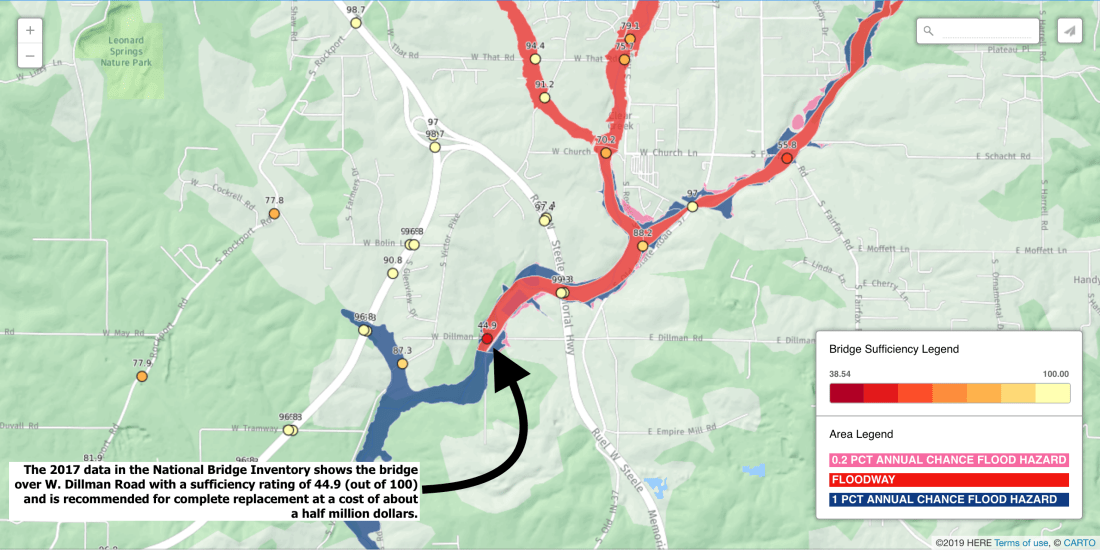
The Dillman Road bridge is one of 224 Monroe County bridges included in the National Bridge Inventory, a database maintained by the Federal Highway Administration.
Based on the latest records available in the NBI, after a March 2016 inspection, the Dillman Road bridge had a “Sufficiency Rating” of 44.9 out of 100. Records in the database show that replacement of the bridge is proposed.
The bridge is on an every-two-year inspection schedule, according to the database. The FHA has not yet posted 2018 NBI numbers online.

The SR for a bridge is calculated with a formula that includes more than 20 variables. Among the factors included in the SR are ratings of the bridge’s deck condition, integrity of the superstructure and substructures, and the distance a detour would require if the bridge were closed.
Based on the SR and the posting requirement shown in the database, the bridge isn’t providing the service that’s needed at that location. It’s posted with a weight limit of 10 tons. What kind of work does the Dillman Road bridge need—to improve it to the point that it can provide the type of service needed at that location?
According to the NBI database, the cure is replacement, not repair. (The Type of Work data for the Dillman Road bridge is “31,” which means “Replacement of bridge or other structure because of substandard load carrying capacity or substandard bridge roadway geometry.”)
The NBI database gives an estimate for the cost of replacement (in 2016 dollars) of $256,000 for the bridge, and another $200,000 for the approaching roadway, for a total project cost of $456,000.
According to the NBI database, the Dillman Road bridge was built in 1910 and reconstructed in 2002.
The Dillman Road bridge is one of the 15 bridges in Monroe County that are proposed to be replaced, according to NBI database records. Another half dozen are proposed to be rehabilitated or have their decks widened.
The 44.9 Sufficiency Rating of the Dillman Road bridge isn’t the worst of Monroe County’s 224 bridges, but it’s among the worst. Just five of the county’s 224 bridges have lower SRs: Harbison Road over Jacks Defeat Creek (38.1); Kinser Pike over Beanblossom Creek (38); Dutch Church Road over Jacks Defeat Creek (36.6); Allen Street over Jordan River (34.9); and Friendship Road over Stephens Creek (28.3).
The priority given to bridge replacement will likely depend in part on the number of vehicles that use the bridge. The average daily traffic for the Dillman Road bridge, measured in 2014, was 558 vehicles
The high water images appearing on social media in the Bloomington area last week—including those of the Dillman Road bridge—appear to correspond mostly to the floodplains identified in maps maintained by the Federal Emergency Management Agency (FEMA). The Dunn Meadow area on the Indiana University campus, for example, lies in the 1 percent annual chance flood hazard area, which is sometimes called the 100-year flood plain.


Comments ()