Analysis: Most Bloomington annexation remonstrance waivers not valid under 2019 law, population density unevenly spread

On Aug. 4, starting at 3 p.m. a public hearing will be held by Bloomington’s city council on eight separate annexation ordinances.
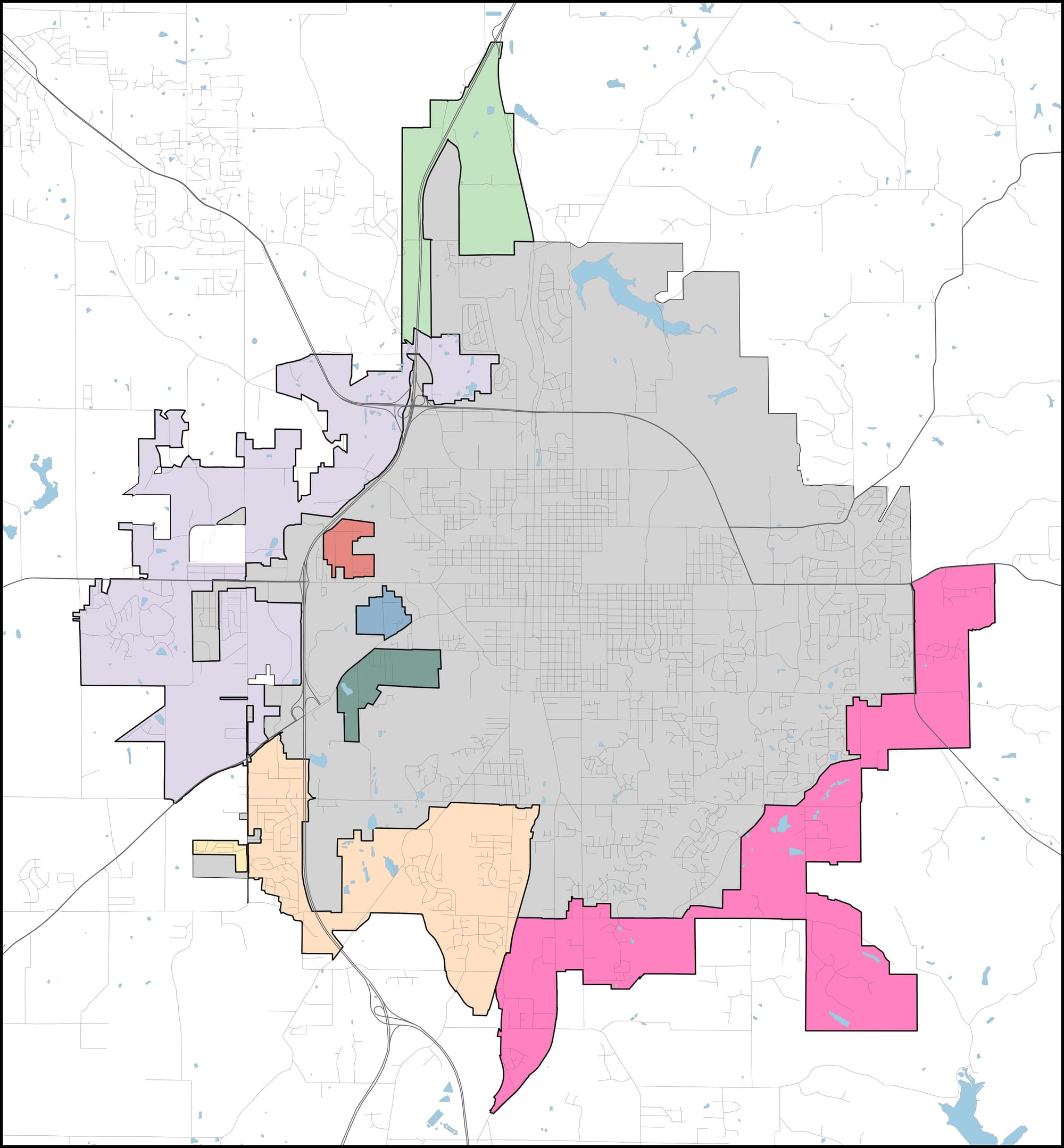
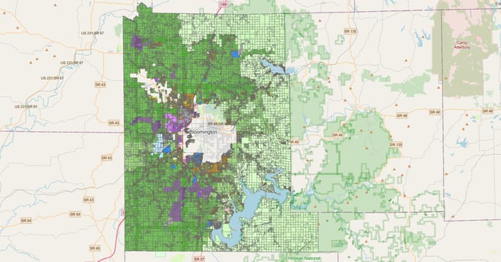
If all eight areas were annexed, more than 9,000 acres and 14,000 people would be added to the city of Bloomington.
In the lead-up to the Aug. 4 hearing, three public meetings have been held to present the findings of a financial consultant, hired by Monroe County commissioners to review the city of Bloomington’s fiscal plan for its proposed annexations of territory.
On those three occasions, much of the energy in the room addressed questions about the process for stopping Bloomington’s annexation plans. And many of those questions have centered on the status of remonstrance waivers.
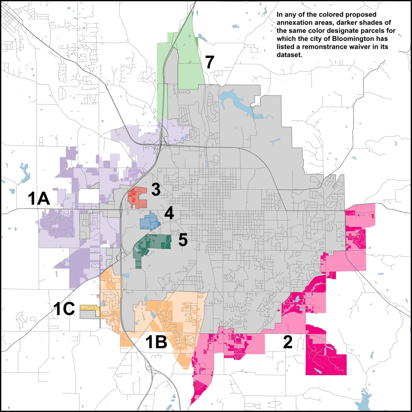
Key to the formal remonstrance process are waivers that might be associated with a parcel. Some parcels have waivers attached. Others don’t.
How many of the waivers are valid? What’s the geographic distribution of parcels that have a waiver? How do parcels with waivers square up with population density?
First, a short answer: The majority of remonstrance waivers look like they’re too old to count under a 2019 law. That means a petition signature from a property owner will likely count under the 2019 law, even if there’s a waiver attached.
Another short answer: The geographic distribution of waivers is uneven, and does not necessarily line up with the measured population density from the 2010 US Census.
Which remonstrance waivers are valid?
One highlight of discussion at the three public meetings on annexation has been the fact that an official remonstrance petition cannot be signed, unless and until Bloomington’s city council enacts an annexation ordinance for a particular area.
An effort by a group called County Residents Against Annexation is circulating petitions in advance of the city council’s votes on the ordinance, with the idea that a strong showing of sentiment against annexation will convince city councilmembers to vote down the ordinances.
If more than 65 percent of property owners in an area sign a remonstrance petition, that would kill a city’s annexation ordinance for that area. If a property has a valid waiver, then that property owner’s signature on a remonstrance petition does not count towards the 65-percent threshold.
County attorney Jeff Cockerill said at Monday’s meeting, there’s no penalty for a property owner who signs a remonstrance petition, if it turns out that a valid waiver is attached to the property.
Based on Bloomington’s dataset of properties for annexation, in four out of the eight areas, more than 35 percent of properties have waivers attached. If all those waivers were valid, that would make it impossible to achieve the 65-percent threshold.
But based on a crowd-sourced review of more than 900 remonstrance waivers—on which Bloomington is relying to defend against possible remonstrance—most of them were signed before July 1, 2003. That would invalidate the waivers under a law enacted in 2019 that voids any remonstration waiver signed before July 1, 2003.
The city of Bloomington says it is proceeding as if the older waivers are valid. The city appears to take the position that because the current annexation process started in 2017—but was interrupted by a new state law, which was found in late 2020 to be unconstitutional—the 2019 law should not apply.
It’s the county auditor, Cathy Smith, who has the statutory responsibility to evaluate any remonstrance petitions. And according to county officials, she will be applying the current statute, which includes the 2019 amendment. It would be up to the city of Bloomington to file a lawsuit, if it wants to disqualify remonstrance signatures, based on waivers that the county auditor has considered to be too old.
The remonstrance waivers on which Bloomington is relying were produced by the city of Bloomington in response to a request made by The B Square under Indiana’s Access to Public Records Act. [Dropbox folder with .pdf files all waivers]
Dates of signing were checked using a shared Google Sheet with links to individual .pdfs of waivers. Nine people who subscribe to the morning B Square Bulletin email message responded to an invitation to help verify the dates when waivers were signed.
Here’s a breakdown, sorted by percentage of properties (low to high) that have waivers more recent than July 1, 2003.
Table: Remonstrance Waivers
| Area | any waiver | waiver after 2003-07-01 | total parcel count | % parcels, any waiver | % parcels w/ waiver after 2003-07-01 |
| 7 | 5 | 0 | 134 | 3.73% | 0.00% |
| 1-C | 102 | 1 | 107 | 95.33% | 0.93% |
| 3 | 32 | 6 | 130 | 24.62% | 4.62% |
| 1-B | 1307 | 167 | 2409 | 54.25% | 6.93% |
| 4 | 19 | 9 | 107 | 17.76% | 8.41% |
| 5 | 37 | 21 | 129 | 28.68% | 16.28% |
| 1-A | 782 | 431 | 1832 | 42.69% | 23.53% |
| 2 | 941 | 458 | 1781 | 52.84% | 25.72% |
Population Density
In the case of Bloomington’s proposed annexation, only three of the eight areas could satisfy an objective condition on population density threshold, mentioned in the state’s annexation statute: a minimum of 3 people per acre.
It’s a condition that could factor into the mix, if the number of remonstrance signatures falls between 50 percent and 65 percent of property owners. In that case, a court would decide whether the city’s proposed annexation should take effect.
It’s the three so-called “island” areas of Bloomington’s planned annexations that have a high enough density to hit the 3-person-per acres threshold. Those are Area 3, Area 4 and Area 5.
Based on acreage and population given in Bloomington’s current FAQ on the topic, here’s the density breakdown.
Table: Population Density
| Area | People | Acres | People/Acre |
| Area 1a (South-West A) | 3,987 | 3,232 | 1.23 |
| Area 1b (South-West B) | 4,566 | 1,755 | 2.60 |
| Area 1c (South-West C) | 79 | 47 | 1.68 |
| Area 2 (South-East) | 3,888 | 2,890 | 1.35 |
| Area 3 (North Island) | 366 | 110 | 3.33 |
| Area 4 (Central Island) | 420 | 93 | 4.52 |
| Area 5 (South Island) | 956 | 232 | 4.12 |
| Area 7 (North) | 115 | 896 | 0.12 |
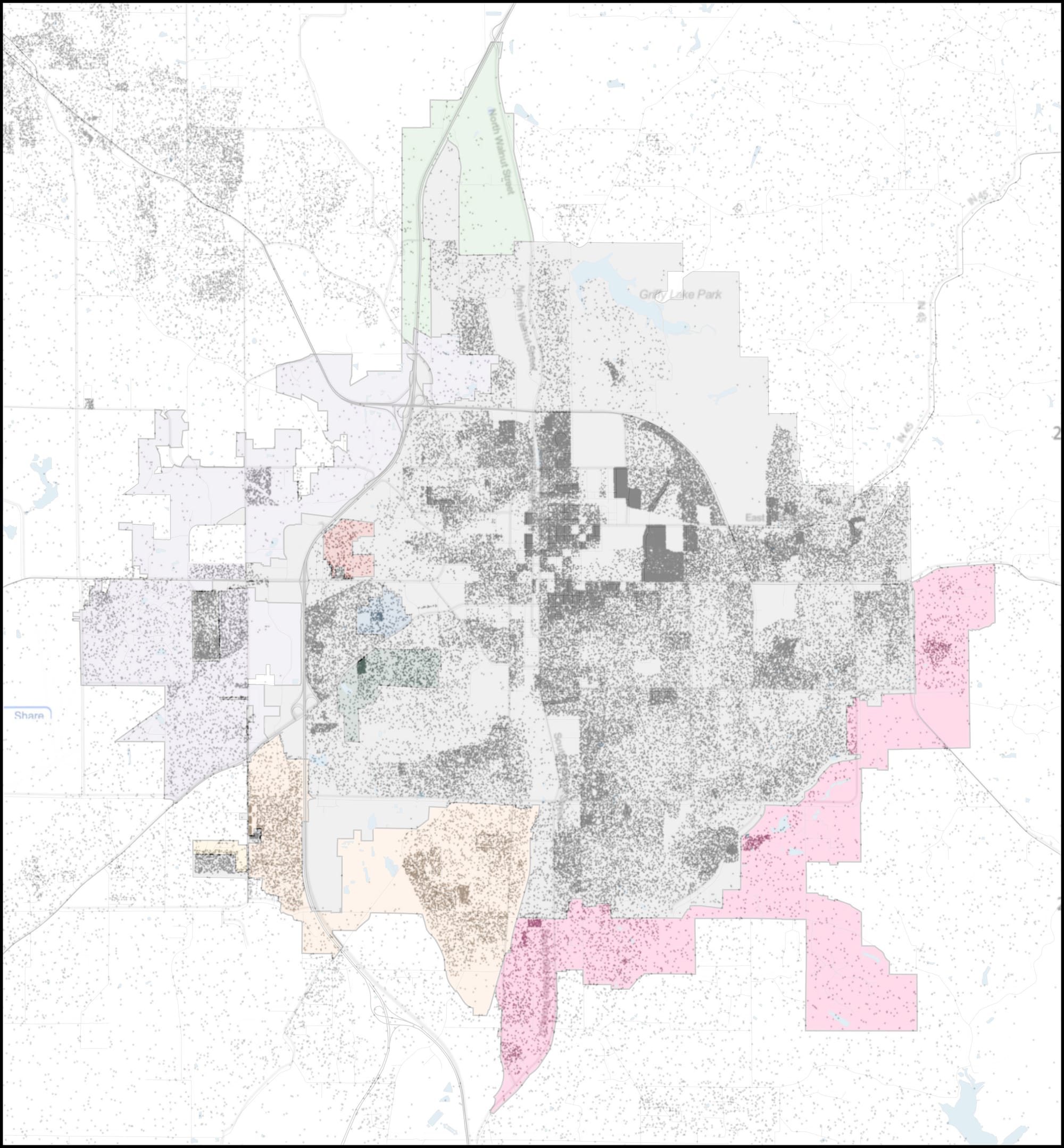
But the population density in the proposed areas is not uniform. Neither is the population inside the city limits.
That’s based on an overlay of a dot map, sourced from the racial dot map produced by the Weldon Cooper Center for Public Service. The dot map is based on 2010 US Census data.
The population density in the proposed annexation areas—as reflected in the 2010 census—is uneven. And it does not necessarily match up with the places where there are signed remonstrance waivers.
The geographic distribution of parcels with attached waivers is also uneven. That’s not a surprise, given that many waivers are associated with developments, and were signed by the developer.
The mismatches between waiver areas and population density could be due, at least in part, to the age of the population data, compared to the waivers. The population data is 10 years old. The set of waivers is of current vintage—some of them are dated as recently as last year.
For the Aug. 4 hearing, the structure of the proceedings will be set by a city council vote at the start. According to the city council’s information packet, one likely outcome would be to give each person a three-minute comment period, to cover any or all of the eight annexation ordinances.


Comments ()