Column: Connecting some annexation dots with Bloomington’s 2020 Census data
A week ago, the US Census released the data from its 2020 decennial count.

Locally, the immediate focus was on Bloomington’s count of 79,168—which came in lower than had been estimated. It was lower even than the 2010 count of 80,405.
A fair amount of effort has already gone into trying to understand why the US Census Bureau’s actual count put Bloomington’s population lower than the same agency’s most recent estimates.
Not receiving as much attention has been the potential utility of the fresh census numbers for Bloomington’s current plans to add territory to the city.
The 2020 Census count outside Bloomington has not been subject to the same kind of skepticism as the area inside the city.
So the population of the proposed annexation areas, as measured by the 2020 Census, could factor into upcoming Bloomington city council deliberations, unimpeded by doubts about accuracy.
Of course, population density (at least 3 people per acre) is just one of the statutory considerations in Indiana’s annexation laws.
Another statutory consideration includes how much of the proposed annexation areas is subdivided or is parceled through separate ownerships into lots or parcels. A third factor mentioned in the state statute is whether the territory is zoned for commercial, business, or industrial uses.
Still, the fresh, fine-grained geographic detail of the census data released last Thursday seems like information that should be incorporated into the Bloomington city council’s deliberative process. Mid-September votes are currently contemplated on each of the eight proposed annexation areas.
It was in late 2020, when Indiana’s Supreme Court ruled unconstitutional a 2017 law enacted by the state legislature to stop Bloomington’s annexation process. Last year, it would have been possible to recognize that a resetting of the Bloomington’s annexation plans would allow for incorporation of the 2020 Census results.
That’s not the path that Bloomington’s mayor, John Hamilton, and the city council are taking. They have picked up this year where the 2017 process left off.
Bloomington’s city council has put off until Aug. 31 its deliberations on possible amendments to the maps. A special meeting has been set for that date.
Map amendments approved on the last day of August would impact each area’s accompanying fiscal plans. That would leave Hamilton’s administration just a couple of weeks to revise those fiscal plans.
Between now and mid-September, when the city council votes on annexation, it would be useful for councilmembers and city staff alike to take a look at the 2020 block-by-block population counts for Monroe County.
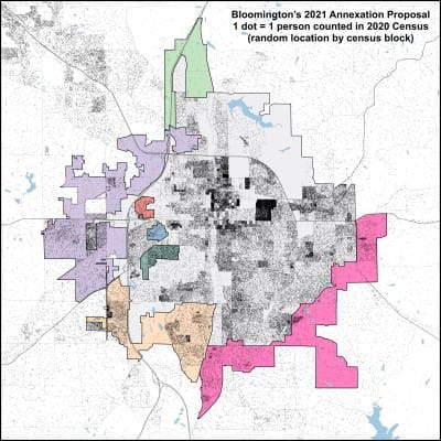
To support that effort, The B Square has plotted a dot map of the 2020 Census count’s distribution, by census block, with an overlay of the proposed annexation areas. The census block is the finest-grained geographic measure available in the data.
Each dot on the map corresponds to one person. The location of each of the 139,718 dots was randomly selected. That is, for a census block with a population of N, the map shows N dots at randomly selected locations inside the area of the census block.
The opacity of a single dot has been set to 25 percent. That means a solitary dot is visible on the map. But if dots overlap—as they will in denser areas—the areas of overlap will be darker.
From the perspective of population density, as shown in the map, do the shapes of the areas that are proposed to be annexed make sense? Should the proposed areas be trimmed back bit? Should they expanded? (For the current process, only a trimming back would be a legal possibility.)
Here’s the map.


Comments ()