2 possible city council maps mulled by Bloomington redistricting commission, but one might not be legal

At Monday night’s meeting of Bloomington’s redistricting commission, just one of the proposed maps drew the initial attention of the five members. By the end of the night, based on a public comment, they’d added a second one to the mix for further consideration.
But the second map might not be legal, because it looks like it leaves one of the districts unconnected to some of its parts. The B Square has inquired with the Indiana state election division’s legal counsel about the legality of the second map.
On Monday, commissioners scheduled two additional meetings to complete their work, which has a deadline of Sept. 7. Under the city’s 2020 ordinance that established the commission, it’s by that date when they have to recommend a new district map to the city council.
The next meeting is set for Wednesday, Aug. 31 at 7:30 p.m. The fifth, and possibly final, meeting of the commission is set for Wednesday, Sept. 7 at 8:15 a.m. It’s possible that the vote on a recommended map could come at the Aug. 31 meeting.
The city council could adopt the recommended map or punt it back to the commission for revision. In any case, the council has to make its redistricting decision by the end of the year.
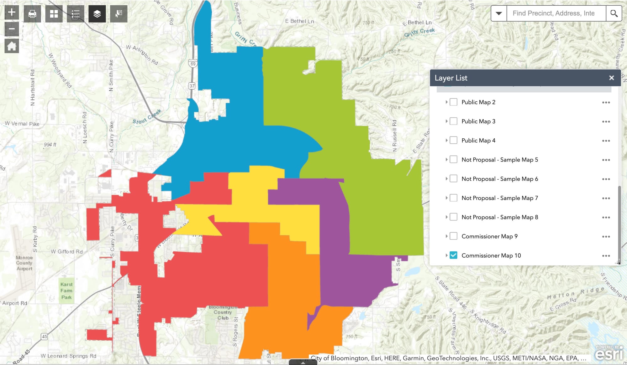
The first map given consideration on Monday was proposed by commissioner Amanda Sheridan—drawn with an eye to preserve as much as possible the existing boundaries for the six city council districts. Of the layers available in the city GIS team’s mapping tool, which was created to support the commission’s work, Sheridan’s map is labeled as Commissioner Map 10.
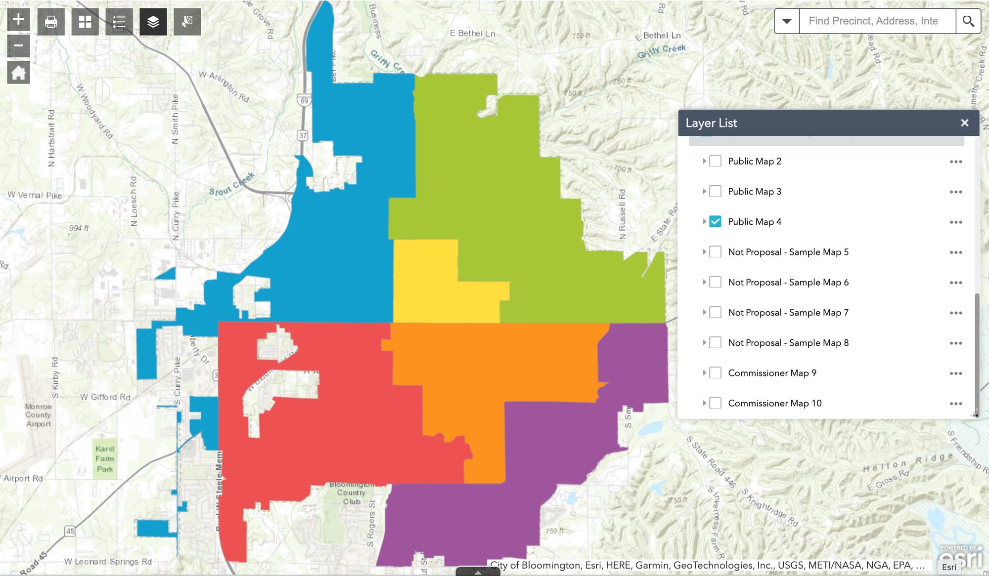
The second map, labeled Public Map 4, was submitted by The B Square, optimized with some help from open-source software called Auto-Redistrict, to split townships across as few districts as possible.
The local ordinance establishing the commission says that the maps are supposed to avoid dividing communities of interest. Communities of interest are defined in the local ordinance as including political subdivisions like townships, as well as “neighborhoods, school districts, historic districts and other areas where residents share common traits and concerns.”
The boundary between the political subdivisions of Perry and Bloomington townships is 3rd Street. So 3rd Street stands out in Map 4 as a clear east-west boundary across the city.
The second map got some consideration after public commentary from former city clerk Regina Moore, who weighed in critically about Map 10, saying that the central (yellow) district in the map covered a span from High Street all the way to the west side of the city. Moore said that particular district has three or four distinct neighborhoods that have nothing in common with each other.
Moore said that to her, Bloomington divides naturally north-south along 3rd Street. Because of that structure, she said, she did not think commissioners should try to draw districts that straddle 3rd Street.
From another public commenter came a question about why commissioners had landed on Map 10 for consideration, and not Map 4, for example, a map that reflected Moore’s commentary about how 3rd Street naturally delineated the city north to south.
Commissioner Kathleen Field asked that Map 4 be displayed on screen. Commission chair Alex Semchuck had concerns about the “compactness” of the blue district on the west side of the city. Field said that part of the map would be “weird” no matter how the map is drawn.

From the chat box on Zoom—the meeting was held in a hybrid in-person-remote platform—came a question about whether the southwest part of the blue district is properly connected to the rest. The unconnected parts of the blue district in Map 4 belong to the same precinct, which is Van Buren 02.
But state law says that city council districts have to be “composed of contiguous territory, except for territory that is not contiguous to any other part of the city;” [IC 36-4-6-3]
One way to conceptualize contiguity is to consider a district to be contiguous if it is possible to walk between any two points A and B inside a district without crossing into a different district. For at least some points A and B in the blue district, it’s possible to walk from A to B and still stay inside the city, but not without crossing into a different district, which does not square up with the notion of contiguity.
The two parts of Van Buren Township Precinct 02 are each contiguous to some part of the city of Bloomington, so their territory does not seem to fall into the exception described in state code.
The B Square has sent in a question to the legal counsel for the state election division asking for some insight into whether Map 4 would pass muster under state law.
If any additional materials related to the Aug. 31 and Sept. 7 meetings of the commission are available, they will be posted on the redistricting commission’s web page.
[Updated Aug. 28, 2022: The Indiana Election Division legal counsel responded to The B Square’s inquiry by saying he could not comment on the legality of the proposed map, but did provide background information about the definition of contiguity. City council attorney Stephen Lucas was still looking to double-check with city GIS staff to confirm that the Van Buren 02 precinct was, in fact, itself disconnected. Lucas indicated that if the precinct is itself disconnected, then he would be pointing out to the commission that in order for a proposed map to be legal, Van Buren 02 would have to be included in the same district as Perry 29—which is where Van Buren 02 touches the city. Based on the shape of Van Buren 02 adopted by county commissioners in 2012, Van Buren 02 is itself disconnected. That is, there is no sliver of roadway that connects the two pieces. Otherwise put, the proposed map does not pass legal muster.]

Comments ()