Column: Let’s put a stop sign on the road to divisive debate club points, greenlight more ped infra money

Last Wednesday, a divided Bloomington city council approved new stop signs on Maxwell Lane at Sheridan Drive, making the intersection an all-way stop.

The council’s deliberations were on brand—mired in meaningless debate club theater. The desire to score debate points distracted from a fundamental challenge—the need to identify more funding for infrastructure that benefits pedestrians.

But there’s an upcoming venue where a need for additional funding pedestrian infrastructure could get aired. Sometime in the next few weeks, the four-member city council sidewalk committee will be conducting its annual review of requests for new sidewalk construction.

The committee will be making recommendations on how to divvy up $336,000, which is the same amount as last year.  But based on 2019 costs, there’s $17 million worth of requests on list for additional sidewalks, which will take a half century to build at the current pace.

I hope the sidewalk committee members take some of their meeting time to start talking about concrete steps the council could take, working with the mayor, to inject more money into pedestrian infrastructure.

Here’s some ideas that could be explored: annually issue $3 million in general obligation bonds targeted for pedestrian infrastructure; tap a portion of the $16 million in CRED (Community Revitalization Enhancement District) fund balances; or use tax increment finance (TIF) revenue, which is overseen by the redevelopment commission.

The vote on the Maxwell-Sheridan stop signs was 6–2 with Steve Volan abstaining—because he could not bring himself to vote for it or against it. Matt Flaherty and Kate Rosenbarger voted against the stop signs, citing the recommendation of city engineer Andrew Cibor, which was based on the MUTCD (Manual on Uniform Traffic Control Devices) standards.

Cibor offered his perspective on more than just the technical attributes of the intersection. He indicated that the intersection could benefit from a narrowing of the roadway, but cautioned, “It starts to get to the question of prioritization of larger capital investments.”

He added, “The trick is we have so many other locations in the city that also have challenging locations for pedestrians to cross or lack of pedestrian facilities at all…”

The council could have taken Cibor’s statement on Wednesday as a cue to come together in their deliberations to talk about identifying more sources of funding for capital investments in pedestrian infrastructure.

Instead of coming together, the council took the chance to find creative ways to divide itself even more.

Here’s one example. Volan decided to try for a cheap debating point by accusing Dave Rollo—his colleague on the council of nearly 19 years, and stop sign ordinance co-sponsor—of failing to provide the required fiscal impact statement that is required under Bloomington’s city code.

Volan’s question to Rollo was: “Is there a fiscal impact statement for this ordinance,…which has definitely revolved around the cost of implementation?”

Rollo said there was not a “formal fiscal impact statement,” but indicated that Cibor had estimated the cost of adding the stop controls for the intersection at $1,000.

Volan’s response: “I’ll just note that the answer is there is no fiscal impact statement. …you didn’t bother to do it.”

In fact, Cibor’s cost estimate was included in the council staff memo on the topic, and the memo was included in the meeting information packet:

Engineering staff provided a rough cost estimate of $1,000 for the installation of all-way stop controls. Staff also noted that a cost estimate for traffic calming devices is difficult to provide without knowing the type or design of traffic calming that might be installed.

Does that count as a fiscal impact statement? Yes.

The reason it counts is that in February 2021 the council gutted the local law requiring a fiscal impact statement for all legislation—by removing the requirement that a standard form be used for the statement.

The council’s action in early 2021 came after The B Square pointed out in late summer of 2020 that the council had not been following the law on fiscal impact statements, which at the time required a form to be filled out.

In February 2021, councilmember Sue Sgambelluri said this about the change to abolish the required fiscal impact statement form: “It provides flexibility and it would no longer force us to kind of shoehorn those reports into a form that is not particularly flexible.”

As a result of the change, Bloomington’s local law on fiscal impact statements no longer mentions a form. The law now reads:  “All proposed legislation must be accompanied by a statement describing the impact of that legislation on the city’s finances, including but not limited to revenues, expenditures, and any new debt obligations.”

After the requirement to use a standard form was abolished, a description in a council staff memo based on a cost estimate from city staff was enough to satisfy the amended law.

Such a description was enough for the council to give unanimous approval to an ordinance in April 2021 that abolished right turns on red at several intersections.  For the no-right-turn-on-red ordinance, here’s what the fiscal impact statement in the council staff memo looked like:

[Public works director Adam Wason] provided a rough estimate of approximately $50 per sign, along with $50 for installation. At a total estimated cost of roughly $100 per installed sign, the total cost associated with new signage would be in the range of $8,000.

If the council’s collective memory extended just to the relatively recent events of February 2021, when the required form for a fiscal impact statement was eliminated, the council could have spared itself at least one distraction during Wednesday’s meeting.

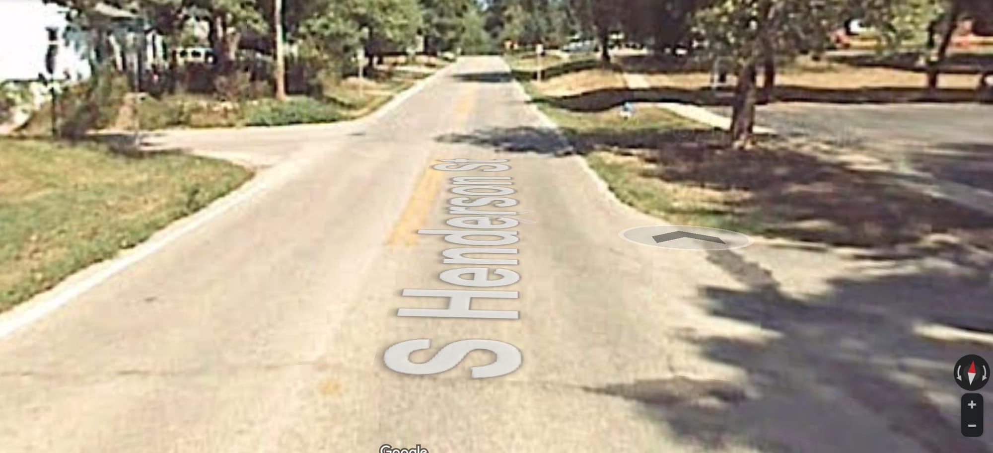
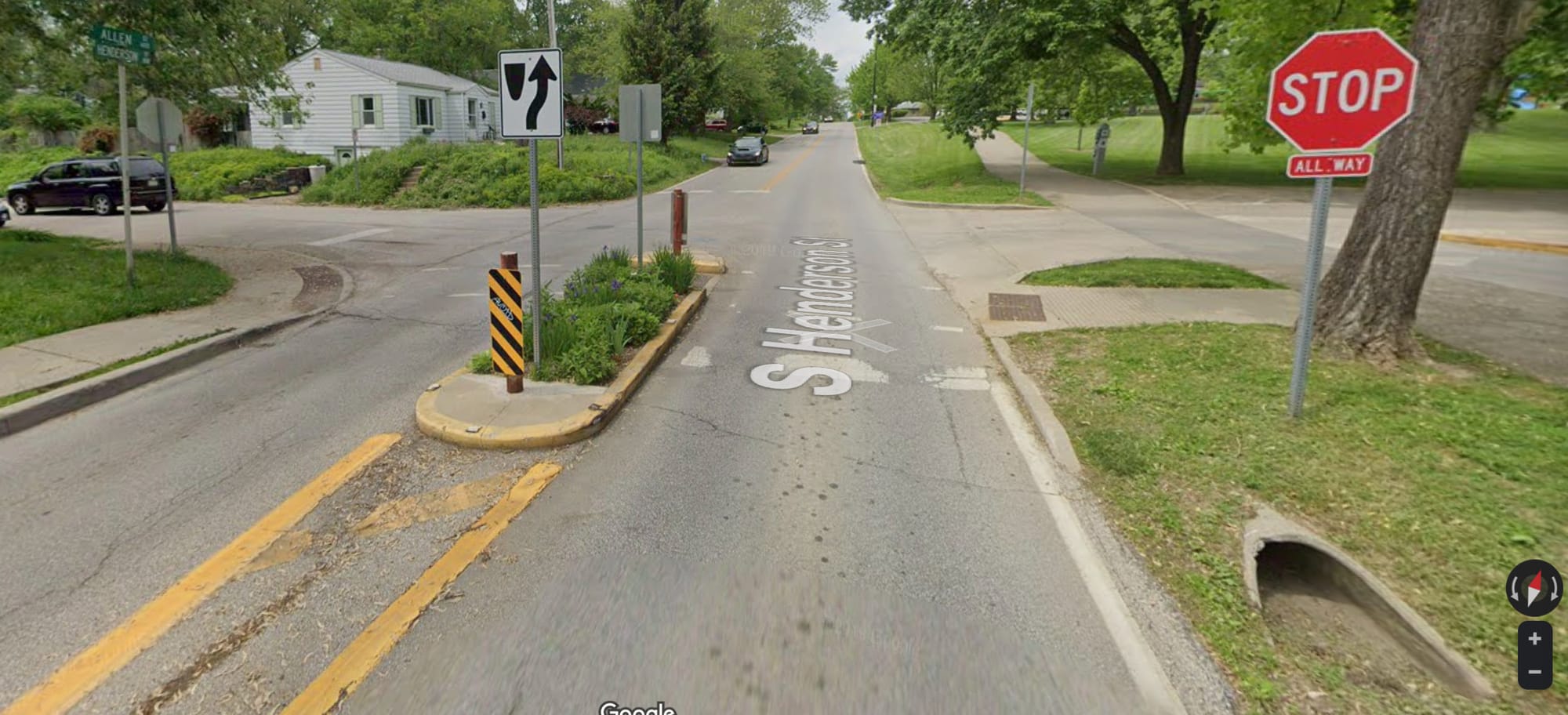
If the council’s collective memory extended as far back as 2008, the deliberations on Wednesday could have been better informed—by a council decision that year to install new stop signs at the intersection of Henderson and Allen streets.

The 2008 edition of the council included four current councilmembers: Dave Rollo, Isabel Piedmont-Smith, Steve Volan, and Susan Sandberg. The council was considering a broader ordinance on changes to the traffic code, and it was Piedmont-Smith who sponsored an amendment, which added the Henderson-Allen stop signs.

Like the Maxwell-Sheridan signs, Henderson-Allen stop signs did not enjoy the city engineer’s recommendation, because they did not meet the MUTCD warrants. But according to Herald-Times coverage, “It was reported that the stop sign was recommended by the city’s traffic commission in order to slow traffic on Henderson which, on average, was found to be going almost twice the legal limit.”

The Henderson-Allen stop signs generated opinions for and against, some of which were published in the H-T.

The H-T editorialized against an infrastructure improvement at the intersection, not the stop signs per se. A pedestrian island had already been installed at a cost of $5,190, according to the paper.  And the pedestrian island and helped to slow traffic, according to the H-T.

But the apparent logic of the op-ed goes something like this: Given that the council approved the installation of stop signs, the money for the pedestrian island had been wasted.

Based on the Google Street View imagery from 2007, which predates the pedestrian island and the stop sign, other improvements were also made in the vicinity of the intersection.

The entrance to the park’s parking lot was moved to align with the intersection, making the driveway entrance one of the stops in a four-way stop configuration. Comparing the Google Street View imagery from 2007 and 2019, it looks like stormwater improvements were also made. A sidewalk on the west side of Henderson was added.

I’m not sure why the H-T analyzed the pedestrian island and the stop sign as an either-or choice.

But choices like that are always harder if the amount of funding for pedestrian infrastructure is not adequate to achieve safety goals. You should be able to walk anywhere you need to go in Bloomington and know you’re safe doing it.

Achieving that goal is going to take more money and attention than Bloomington currently invests in pedestrian infrastructure.

I wish city councilmembers would come together to head in that direction. There’s nothing stopping them except for a lack of political will.

4 thoughts on “Column: Let’s put a stop sign on the road to divisive debate club points, greenlight more ped infra money

  1. Thanks for the background on the fiscal impact statement.

    Andrew Cibor said he was uncomfortable using the word ‘safe’. I think what he was getting at was the same sort of thing that Aaron Carroll talked about in the context of Covid: there is always risk but there are things you can do to reduce the risk to a point where one can bear the risk.

    Clearly there are a lot of places in Bloomington where people are uncomfortable with the risk associated with walking. Equally clearly reducing that risk is not a priority for the current administration.

    Instead we are offered the over engineered, expensive Hawthorn-Weatherstone Greenway. Lots of money for superfluous pinch curbs, speed bumps and duplication of a connection to Weatherstone, but nothing to address the intersection of Hawthorn and Atwater, which is the only really difficult point on the route.

    Neighbors were underwhelmed, to say the least, at the most recent neighborhood input meeting about the greenway and questioned why so much money is available for unnecessary alterations to the Greenway and so little is available for pedestrian infrastructure.

    Rather than additional general obligation bonds wouldn’t it be better to use the money we have more wisely? Atwater and Highland is another intersection that presents challenges due to a hill. Wouldn’t the money for the Hawthorn Greenway be better spent improving the intersection at Atwater and Highland? This would improve access for bikers to the existing Highland to Weatherstone connection and improve pedestrian safety as well.

    Other neighborhoods could no doubt provide similar ideas about other intersections.

    We also need to broaden the information used to assess safety beyond BPD crash reports, as indicated by the two ambulance runs at Sheridan and Maxwell reported by Kerry Thompson that Andrew Cibor was apparently unaware of.

    1. Hello William – I’m Greg! Somehow we’ve never met. I’m a close friend of the son of Jim Klopfenstein, who I infer that you might have worked with.

      I’m disappointed to see opposition to the Hawthorne greenway juxtaposed with asking the city to do something for pedestrian safety. I want to share a little of the history of the plans that went into prioritizing the Hawthorn greenway.

      The 2018 comprehensive plan ( https://bloomington.in.gov/planning/comprehensive-plan ) generally says that bike & ped transportation should be treated as if they are important, and calls for a transportation plan to be developed to reflect those goals. The consultants for the transportation plan ( https://bloomington.in.gov/transportation/plan ) took this goal from the comp plan, conducted surveys of people and of existing infrastructure, and then created the plan they did. It’s an excellent plan and you’re obviously someone willing to thoroughly investigate a document so I beg you to look at it.

      One of the most ambitious parts of the transportation plan is restoring two-way circulation on 3rd/Atwater and Walnut/College. This mandate was somewhat watered down to a “corridor study”, but the core idea is there: these streets need to be designed with a focus on bike / walk / bus, and driving needs to be deemphasized. Whether that means restoring two-way circulation or not is an open question, but radical change is absolutely required. I am glad you identified Atwater & Hawthorne as a problem — this plan does so as well!

      Those corridor studies are in process now. I wish I had some inside information but I don’t — I have the general idea we’re going to get a report on 3rd/Atwater in the next year, and Walnut/College about a year after that. Those corridor studies are going to guide the engineering department (working with Public Works, the MPO, and maybe the RDC etc) to consider expenditures on the order of $10-$30 million dollars. “A large capital project.” That kind of expenditure on important corridors is typical, but also can only happen at a certain rate…the city will typically see one or two of these larger capital projects in a decade. This is the first time since about 1950 that the large capital improvement budget is going to be spent on something other than road widening for cars, and it is a big deal. A huge progress.

      The greenway projects are the opposite of that large capital process. Planning staff oversees on the order of half a million dollars annually, with the mandate of completing the plan’s “priority bicycle facilities network”. From my perspective, it looks like they are trying to stretch this money to cover about two different 1-mile segments of greenways per year. Which is about the rate they need in order to achieve a significant fraction of the goals from the transportation plan. The greenways plan aims to produce a network of relatively low-stress / low-speed streets, and specifically to address gaps in the existing grid streets, such as the gaps that define the south border of Elm Heights.

      So they are forming a grid out of east-west connections: 17th St, 7th St, Smith/Hunter, Allen/Covenanter, and Black Lumber/Thornton Dr. And north-south connections: B-line, Indiana/Henderson, Fee / Hawthorne / Weatherstone / Highland, and Clarizz. It’s not perfect but the goal is that anyone making a trip inside of the city will be able to travel less than half a mile to get to the low-stress network, and then the low-stress network should get them within half a mile of their destination.

      Contrary to your suggestion, this process is the opposite of “over-engineered.” In order to improve 2 miles of corridor per year, they are extremely limited in the kind of things they can do. They can install some horizontal / vertical traffic calming. They can install new signs or paint at intersections. And they can afford a very small amount of new-path construction, like a 6′ wide by 100′ long asphalt path connecting two cul-de-sacs. They absolutely cannot afford any drainage / utilities work (which rules out most sidewalk projects), and revisiting even a single intersection on a major corridor (such as Atwater) would easily blow the whole annual budget. So they have a mandate to provide a cohesive network across the whole city for about $3 million (half a million a year, spread over 6 years). And, given those constraints, I think they are doing a bang-up job.

      I want to be clear about what this isn’t, though. It’s not about finding problem spots and fixing them — they need to develop a whole frickin network with this money. And it’s not about establishing fully-segregated facilities like the Jackson Creek Trail.

      To help you understand the need for this grid, the Jackson Creek Trail is a good starting point. It’s almost 100% useless as transportation. I’ve been trying to find a reason to use it — recreational or utility — since it was built and I simply couldn’t find a trip where it would be even slightly useful. Until last year, when I broke my wrist and had to make a few trips to IU Health Sport & Ortho in the far south-east. I was delighted to see that I could take a trail by the Winslow YMCA, then neighborhood streets, then Jackson Creek Trail, then neighborhood streets, and only have a small amount of pain on Sare to reach my final destination.

      But I had a problem, how to get to the Winslow YMCA? And ultimately what I wound up riding a short distance on South Henderson, and then on Miller Dr. Those roads are not the worst roads on town but they are pretty bad and if you use them regularly as a cyclist or pedestrian then you will become discouraged. There actually were a couple routes through Elm Heights that I considered, but they were so far out of my way, and those neighborhood streets so relatively high strees, than half a mile on Miller Dr didn’t seem so bad by comparison.

      In five years, when the bicycle priority network is mostly built out, I expect to be able to eliminate that stress point from my trip. And the Hawthorne project is an important part of that network. When you’re building a network, there has to be some connectivity. You cannot simply pick and chose by which neighborhoods are progressive, without destroying the cohesiveness of the grid that they’re trying to build. And right now, Elm Heights represents a big hole in the grid, and the closest such hole to downtown or campus. It’s essential that connectivity is established across Elm Heights. It’s the priority part of the project for good reason!

      I hope that process of fixing Atwater as a whole receives your full-throated support and that this instance of you raising concerns about individual intersections along Atwater is not mere concern trolling, designed to derail pedestrian infrastructure and for no other purpose!

      Thanks – Greg

      1. Thanks Greg for your detailed post. Not concern trolling, I cross Atwater regularly, generally at Park because visibility is good and it is near home.

        Bought a bike in 1976 and rode it in Bloomington for 40 years, but no longer comfortable doing so. As I recall, Hawthorn was an easy ride (except for Atwater), so I don’t see a lot of value in the many pinch curbs and speed bumps that are planned.

        And like Christie below, over the years I’ve lost confidence in the city’s ability to prioritize pedestrian and bicycle traffic, especially after the 7-Line was unveiled.

  2. I wish I could be inspired by city politics, but I find it so disillusioning and, frankly, boring. Every year seems to bring the same ideas and squabbles. Bloomington purports to be a progressive town, with an eye toward doing our part to fight climate-change and to making the city more walkable (which also helps with climate change), but, as someone who has lived here since 1998 (minus three years from 2002-2005), any change I have seen is incremental at best. When I returned to Bloomington in 2005 after living in Vermont (home of Burlington, where visionaries closed down a main street to make what is now a beautiful and successful pedestrian mall: https://churchstmarketplace.com/history) and then Europe, I spend a lot of my time advocating for better infrastructure for pedestrians and cyclists. I had hoped for and envisioned a Copenhagen-esque city, where government officials would close down Kirkwood for a Stroget (https://www.visitcopenhagen.com/copenhagen/activities/stroget-main-shopping-street) like atmosphere. I volunteered for the Pedestrian-Bicycle Safety commission and advocated hard for segregated/dedicated bike lanes, knowing from many of my own friends that proximity to cars (i.e. smashed between moving ones and parked ones) was a disincentive to riding. I found the process of trying to work with the city to be horrendous. There is a plan for this and a plan for that, and let’s look at what the goals are and let’s pay some consultants to decide this, and does it match with the MUTCD? I am totally over the process. I have no faith that any of our leaders has the vision to truly reform and remake our city in a way that can help fight and mitigate against climate disaster. Also, frankly, cars are noisy, ugly, smelly, and bothersome, but no one else seems to want to fight for a vision where we all ride our bikes or walk (or take public transport) to where we need to go. It takes vision to make change. Amsterdam, Copenhagen, weren’t special. They had leaders with vision. But, I’m sorry to say, I don’t see any vision in our current leadership. Otherwise, we might have something like this:
    https://www.youtube.com/watch?v=uVhYcJH_m5o
    or this:
    https://www.youtube.com/watch?v=8NUgB_xkIvU
    or this:
    http://www.copenhagenize.com/2011/10/bicycle-rush-hour-copenhagen.html

Comments are closed.