Huge population variance leads MCCSC to mull proposal for new board seat district map
In 2024, anyone who wants to win election to a board seat for the Monroe County Community School Corporation (MCCSC) will likely be navigating by a district map that is different from the current one.

That’s because some changes to MCCSC’s governing plan are set to get a vote by the seven-member board at its regular monthly meeting on Tuesday night.
It’s the governing plan for MCCSC that needs to be amended in order to change the board seat district boundaries. (Attendance boundaries for specific schools are not related to this discussion.)
The board kicked off the redistricting process by adopting a resolution at the start of 2023. The resolution stated, in part, that the board “does hereby commit to commencing with the process of board district realignment.”
It was in 1994, nearly three decades ago, when MCCSC last set its board district boundaries.
But it’s not just the pure passage of time that has led the board finally to consider redrawing the boundaries. It’s because after 30 years, with no adjustments made to the boundaries, the relative population figures for the board districts are now dramatically out of whack.
Based on the 2020 census numbers, the board districts show a whopping 72.5 percent population variance.

The variance is the number you get by taking the biggest population of any district (25,512), subtracting the smallest population of any district (12,912), and dividing by the average population (17,383). To arrive at those figures, The B Square overlaid 2020 census blocks with the current MCCSC district boundaries.
The accepted legal standard for a defensible population variance is a number less than 10 percent. The new map that the board is looking to adopt at its Tuesday meeting shows a variance of just 3.8 percent.
It’s the dramatic variance in population across the current districts that has the board looking to draw up new districts.
The board wants to get the work done before the next window for declaring a school board candidacy starts, in mid-May of 2024. That’s a couple of months earlier than in the past, because of SB 177, which was enacted by the state legislature during its 2023 session.
But under state education law, Tuesday’s vote on the amendments to the governing plan would be just the first step. After that, there’s a 120-day remonstrance period. Then the state has up to 60 days to review the new plan,
| Current Boundaries | Plan A Boundaries | |
| District | 2020 Census Pop (est.) | 2020 Census Pop |
| 1 | 14,692 | 17,687 |
| 2 | 25,512 | 17,025 |
| 3 | 22,220 | 17,478 |
| 4 | 14,959 | 17,119 |
| 5 | 12,912 | 17,349 |
| 6 | 14,592 | 17,638 |
| 7 | 16,788 | 17,383 |
| Max | 25,512 | 17,687 |
| Min | 12,912 | 17,025 |
| Variance | 72.49% | 3.81% |
Under state education law, MCCSC does not have to undertake a regular redistricting process with every decennial census.
That’s because MCCSC board districts are so-called “residential districts”—which determine only where someone has to live, in order to run for a particular board seat. Election to any board seat is by all voters who live within the corporation boundaries, not just those who live within the board seat district.
It’s the same way that the three county commissioners are elected. There are three residential districts for Monroe County commissioners, but all voters in the county vote for each commissioner seat.
Under Indiana state education law [IC 20-23-8-8], it is only school corporations with “electoral districts” as a part of their governing plan that have to undertake regular redistricting:
(4) If the plan provides for electoral districts, where a member of the governing body is elected solely by the voters of a single district, the districts must be as near as practicable equal in population. The districts shall be reapportioned and their boundaries:
(A) changed, if necessary; or
(B) recertified, if changes are not necessary;
by resolution of the governing body not later than December 31 of the year next following the year in which a decennial census is taken to preserve the equality of the governing body.
There have been no adjustments to balance out the population in MCCSC districts over the last 30 years, because there is no legal requirement that it be done.
MCCSC legal counsel is relying on the lack of any legal requirement that districts be redrawn, for its analysis of a specific election law on the timing of redistricting—as not applicable to MCCSC’s effort to redraw the board district boundaries.
Indiana election law [IC 3-5-10-7] says that school corporations can undertake redistricting only in the year following a decennial census. Even with the extra year amended into the statute to accommodate the COVID-19 pandemic, that would still put MCCSC’s effort to redraw the district boundaries outside the statutorily required timeframe.
But in his response to a B Square question about the applicability of that election law, MCCSC superintendent Jeff Hauswald noted that it applies “when a redistricting authority is required by law to redraw election districts.”
Specifically, the election law defines the term “redistricting authority” as “the body or other authority that is required to redraw election districts for local or school board offices.” The argument goes something like this: The election law sets out a timeframe for a redistricting authority to redraw election districts—but because the MCCSC board, with its residential districts, is not required to redraw districts, it is not a “redistricting authority” as defined by election law.
So it looks like the MCCSC board is undertaking the redrawing of district boundaries not as a “redistricting authority” under state election law, but rather as a school board that is amending its governing plan under state education law.
Not currently contemplated by the board is the possibility of amending the governing plan to change some of the board districts to electoral districts and making others at-large districts.
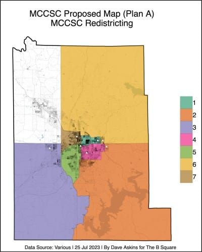
The district map that the board will consider adopting on Tuesday is one of three options from a report delivered to MCCSC by the Indiana Business Research Center (IBRC) at the Indiana University Kelley School of Business. The report and supporting documents were posted on the MCCSC website starting on July 7 for public comment.
The option that is up for adoption on Tuesday night is labeled Plan A in the IBRC’s report.
Plan A and Plan B in the IBRC’s report were generated based on census blocks, not the more familiar precincts. Plan C was developed using precinct boundaries.
The use of precincts to build boundaries is a requirement for some other kinds of districts, like those for city council—except in unusual circumstances.
Census blocks are smaller than precincts. There are 69 precincts in the part of Monroe County that is covered by MCCSC territory. But there are 1,984 census blocks.
Their smaller size means that if districts are built out of census blocks, much greater precision can be achieved for population balance.
Plan C, which has districts built out of precincts, has a variance of 7.6 percent, compared to a variance of 3.8 percent for Plan A, which has districts built out of census blocks.
A question arising out of the IBRC report is how much, if any, consideration was given to the seven incumbents, as the map options were developed. The report states: “While not a primary requirement, the proposed maps do not move current board members out of their current districts.”
It’s not clear if any instruction was given to IBRC to try to avoid putting more than one incumbent in any of the new proposed districts—if not as a primary requirement, then as a kind of secondary requirement.
IBRC’s report also states: “The Monroe County Community School Corporation (MCCSC) contracted with the Indiana Business Research Center for assistance in drawing new school board districts.”
To learn what the expectations were for the redistricting work, The B Square made a request under Indiana’s Access to Public Records Act (APRA) for the contract between MCCSC and IBRC.
The APRA request came up empty. According to MCCSC, “We do not currently have a contract with Indiana Business Research Center (IRBC). We anticipate receiving an invoice from IBRC in the coming weeks and hope to place this on our July 25th agenda.”
As of July 24, B Square was not able to identify an item corresponding to IBRC’s work among the standard set of claims on the July 25 agenda.
What kind of population variance is achievable for MCCSC districts, if consideration is given only to population balance, contiguity, and some degree of compactness? To find out, The B Square loaded up a free, open-source software package called Auto-Redistrict with the data for MCCSC’s geographic areas.
After chugging through thousands of iterations to evolve optimal maps, here are two maps that Auto-Redistrict generated—one based on census blocks and the other based on precincts.
The Auto-Redistrict precinct-based map came in with a variance of 3.69 percent, a smidgen lower even than the census block map produced by IBRC.
The Auto-Redistrict map that was based on census blocks came in with a variance of just 0.03 percent.


| BSquare Census Blocks | BSquare Precincts | |
| District | 2020 Census | 2020 Census |
| 1 | 17,381 | 17,415 |
| 2 | 17,382 | 17,042 |
| 3 | 17,381 | 17,683 |
| 4 | 17,386 | 17,654 |
| 5 | 17,381 | 17,611 |
| 6 | 17,381 | 17,127 |
| 7 | 17,387 | 17,147 |
| Max | 17,387 | 17,683 |
| Min | 17,381 | 17,042 |
| Variance | 0.03% | 3.69% |


Comments ()