Analysis: Bloomington OKs public offering of Hopewell land with apparent mistake in description

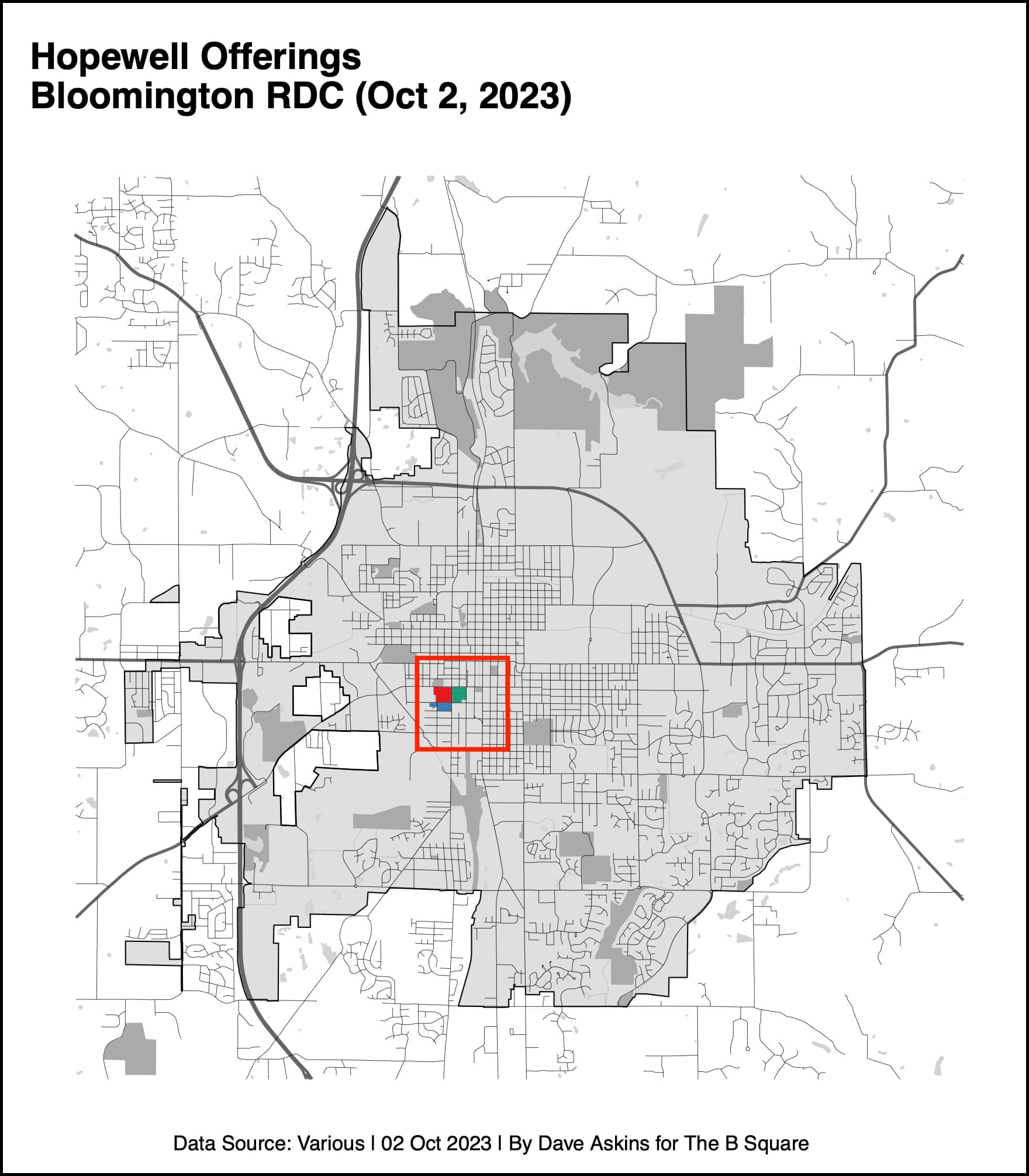
At its regular Monday meeting, Bloomington’s redevelopment commission (RDC) approved a public offering of property south of 1st Street opposite the location of the former IU Health hospital.
Responding to a question raised by The B Square, about the accuracy of the textual description of the three separate pieces of land, the board amended their motion on the offering before adopting it.
The new motion required city staff to add a map—one that is labeled numerically for each of the three parcels.
Based on the map that the board asked to be added, it might be possible to tell exactly what land the city is putting up for sale.
But an apparent mistake in the textual description was allowed to remain.
The city’s RDC controls the property, as part of a $6.5-million deal with IU Health to purchase it. The new neighborhood to be developed there is called Hopewell.
For purposes of the offering approved on Monday, the land was divided into three parts, numbered from east to west, with minimum bids for each part: Block 8 ($1,448,350), Block 9 ($1,448,350), and Block 10 ($664,030).
That made the total minimum bid for all three blocks $3,560,730.
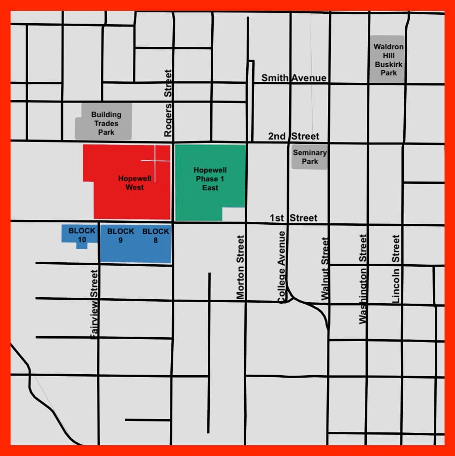
Two of the blocks—Block 8 and Block 9—are supposed to split a single parcel that has just one 18-digit parcel number. The one parcel, with its 18-digit parcel number, spans the block from Rogers Street on the east to Fairview Street on the west. It’s bounded on the north by 1st Street and the south by Wylie Street.
The RDC’s intent is to build a north-south street, to be called Jackson Street, through the middle of the parcel—in alignment with the existing Jackson Street, which runs northward from Smith Avenue near Building Trades Park.
Based on other documents developed by the RDC, Block 8 and Block 9 are supposed to occupy the east and west halves of the block, respectively, when it is divided by the planned new Jackson Street.
A split block is consistent with the minimum bids for the blocks, which are identical at $1,448,350 each.
But the description of Block 8 in the public offering , which was approved by the RDC on Monday, reads like this:
Block 8 (approximately 2.0 acres) located south of 1st Street between S. Fairview and Rogers Streets;
That indicates that Block 8 spans the whole area between Fairview and Rogers—which is inconsistent with the indicated acreage. Here’s a B Square map that matches the textual description:

Block 9 is described in the offering like this, with a reference to the future Jackson Street:
…Block 9 (approximately 2.2 acres) located south of 1st Street between S. Fairview and S. Jackson Streets.
Here’s a B Square map that matches the textual description for Block 9:

The description for Block 9 in the approved offering looks like it squares up with the intended splitting of the block.
To make the description of Block 8 parallel with the description of Block 9, and to make it consistent with the intended block split, it could be revised to read: “Block 8 (approximately 2.0 acres) located south of 1st Street between S. Fairview S. Jackson and Rogers Streets; ”
That would result in textual descriptions that are consistent with the following map:

At Monday’s RDC meeting, there appeared to be no interest from city staff or RDC members in revising the text of the block description.
Deb Hutton questioned how one parcel, with one parcel number, could be assigned two different block numbers for purposes of the offering—while the third part, Block 10, has two different parcel numbers.
But the fact of the apparent flaw in the description of Block 8 did not get aired, until The B Square pointed out the problem from the public mic. The B Square’s question: “Is that a mistake? And is it going to get corrected? Or is that fine?”
Five hours before the RDC meeting, The B Square had alerted staff—housing and neighborhood development (HAND) department director John Zody, as well as deputy mayor Larry Allen—about the apparent mistake in the description. Allen is a former assistant city attorney, who until recently provided legal counsel to the RDC.
Zody responded to The B Square’s question at Monday’s meeting by indicating that he had “huddled” with assistant attorney Heather Lacy on the issue. The important legal consideration is tied to the parcel number, Zody said, not the textual description.
The question was put to Lacy, who repeated Zody’s idea that it is the parcel number that is important, not the words in the description. “The parcel numbers are what will carry the day,” Lacy said.
The board did not press Lacy on the question of how the one parcel number, which in the county’s GIS system refers to a swath of land from Fairview to Rogers, would refute the Block 8 description that has it going from Fairview to Rogers.
Lacy added that the descriptions of Block 8 and Block 9 in the public offering are the same as those in the city’s request for information. (The description of Block 8 in the RFI contains the same apparent error as in the public offering.)
Lacy also said that the labeling is confusing. She said, “It is a little confusing in that we refer to those areas as Blocks 8, 9 and 10.” She added, “So three parcels. But in reality, it’s kind of two areas—areas C and D.”
The labels C and D are from a map that is contained in an exhibit that is supposed to be included with the notice of public offering. Here’s the map:
The pixelated character of the image is in the original from the RDC’s meeting information packet.
RDC member Deborah Myerson suggested including with the notice of offering a different map—one that labels the land not with letters but with block numbers—the same way the notice of public offering does.
Myerson made her motion to approve the notice of offerings, contingent on the inclusion of a map that is labeled with something like Block 8, Block 9, and Block 10.
The RDC’s original request for information (RFI) on the properties includes a map like the one Myerson described. Here’s what that map from the RFI looks like:

The deadline for submission of bids in response to the offering approved by the RDC on Monday is at noon on Nov. 1, 2023.

Comments ()