County contracts for required appraisals for possible land deal to create limestone heritage site

At its regular Wednesday morning meeting, the Monroe County board of commissioners approved a $7,900 contract with Integra Realty Resources for an appraisal of some land northwest of the interchange of I-69 and SR-46. The county is thinking of purchasing the land, which includes several quarry holes, for use as a limestone heritage site.
It’s the second appraisal contract that the commissioners have approved for the same land. At their regular meeting on Wednesday, Sept. 25, the county commissioners approved a $5,520 contract with First Appraisal Group, Inc. for the first set of appraisals.
At Wednesday’s meeting, county attorney Jeff Cockerill reminded commissioners that in order to buy the property, two appraisals are required, and the county can’t pay more than the average of the appraised value.Cockerill’s explanation of the price difference of the appraisals—$5,250 compared to $7,900— drew a question from commissioner Lee Jones. Cockerill said Integra had more experience appraising environmentally sensitive property—that’s why their cost was more than First Appraisal. Jones pointed out that the letter from the appraiser disavows environmental expertise:
Please be advised that we are not experts in the areas of building inspection (including mold), environmental hazards, ADA compliance or wetlands. Therefore, unless we have been provided with appropriate third-party expert reports, the appraisals will assume that there are no environmental, wetlands, or ADA compliance problems.
Cockerill responded by saying that meant Integra is not holding themselves out as people who themselves have environmental expertise. They’re not performing an environmental review, Cockerill said, and the county is not expecting to find out new information that would be in an environmental report.
The environmental history of the land has caused county councilor Marty Hawk to express her opposition to purchasing it. It’s has come up as a topic in front of the county council at least twice—at an initial presentation of general obligation bond projects and at a work session held a couple weeks later.
At Wednesday’s meeting, Cockerill mentioned the aspect of one of the parcels that has drawn Hawk’s concern—an environmental restrictive covenant that recites its history as part of an area polluted with PCBs:
The Real Estate is part of an area designated by the U.S. Environmental Protection Agency (EPA) as the Bennett’s Dump Superfund Site (Site). In September 1984, EPA placed the Site on its National Priorities List (40 C.F.R. part 300, Appendix B) pursuant to the federal Comprehensive Environmental Response, Compensation and Liability Act (CERCLA) because the Site had been impacted by polychlorinated biphenyls (PCBs). In 1985, Westinghouse Electric Corporation, a predecessor to CBS Corporation (CBS), entered into a Consent Decree, as amended, with EPA, the Indiana Department of Environmental Management (IDEM),Monroe County and the City of Bloomington to remediate the Site.
For the western portion of the site, no restrictions apply on the use of the land.
Restrictions on the central and eastern parts of the parcel involve a prohibition against changes to the remediation pipes that are in place. Also prohibited is any development that affects drainage to or from the site, or changes in the water levels in the quarry holes.
When the topic came up at the county council’s work session last week, councilor Geoff McKim said that the parcels the county is considering for purchase don’t include the one that was the source of the PCB pollution.
The $1.4-million figure for land acquisition in the bond project presentation to the county council was based on the asking price of the different property owners, plus the cost of appraisers, and all other costs that would be associated with a land deal, Cockerill said at that work session.
The collection of parcels has three different owners. Asking price for the two northern sets is $250,000 each. The asking price for a larger, 166-acre offering, which includes the 70 acres the county is considering, is $2.7 million.
The 166-acre figure in the appraiser’s document drew a question at Wednesday’s meeting. Was the parcel the county was considering really that big? No, Cockerill said, and he would be using the parcel ID numbers as a guide.

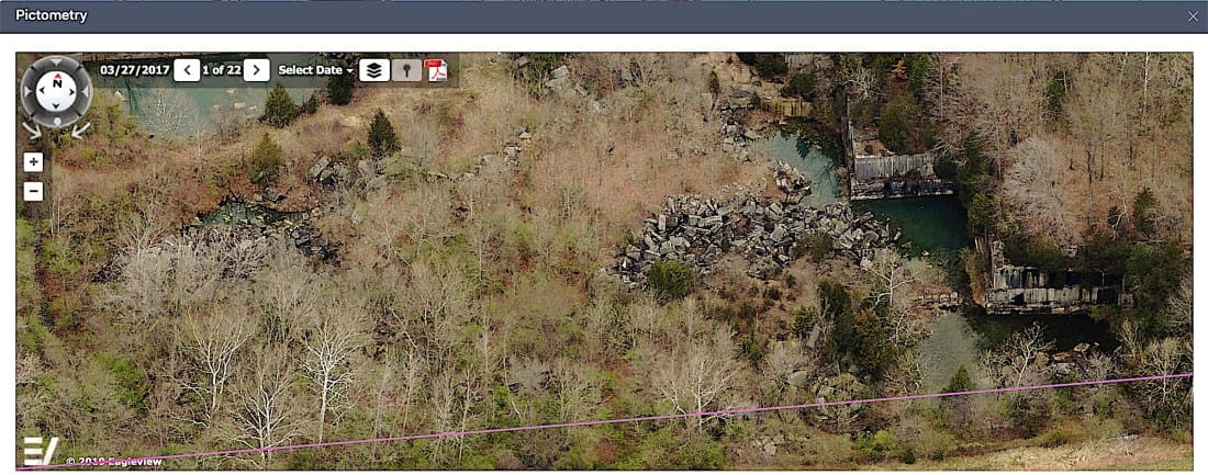
Related to real property at Wednesday’s meeting was an item that approved a six-year $362,320 contract with Pictometry to provide flyover imagery for the county’s Geographic Information System. The contract covers a flyover every two years. The first one tis scheduled for spring of 2020.
When planner Jackie Nester took the podium to introduce a rezoning petition, she took the occasion to express her support for the Pictometry contract. “We use that all the time to help people locate new structures on their property…It helps with environmental preservation and construction process,” she said. Another positive for Pictometry, pointed out by Nester, is that the images are accessible and free to the public through the county’s GIS website.


Comments ()