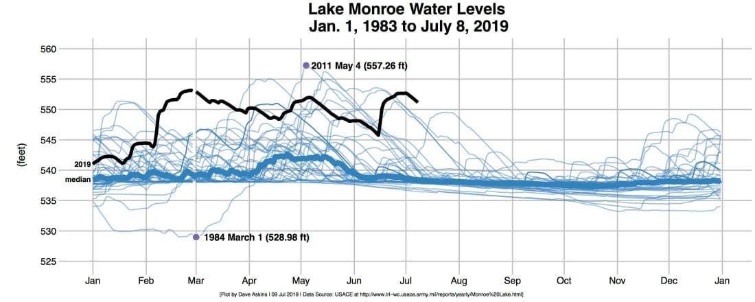
Lake Monroe Water Levels

Chart of Current Year Against Previous Years
Water Level Data Sources
The current water level of Lake Monroe is available in 5-minute intervals from the USGS online gauge. Historical data, back to 1983, is available in 6-hour increments.
- Current realtime: USGS gauge at Lake Monroe in Harrodsburg (5-minute increments)
- Historical: Annual USACE Reports for Lake Monroe (6-hour increments)
Downstream Levels (max gauge height for more Lake Monroe dam releases):
The annual lake reports (see above) include rates of outflow. To release more water than the minimum 200 cfs, downstream gauges have to read lower than minor flood stage, which is 20 feet in Bedford and Shoals, and 16 feet in Petersburg.
Levels of USGS gauges can be checked individually or all in one go.
- Realtime: USGS gauge at White River in Bedford (20 feet)
- Realtime: USGS gauge at White River in Shoals (20 feet)
- Realtime: USGS Gauge at White River in Petersburg (16 feet)
- Realtime three-way plot of USGS gauges at White River in Bedford, Shoals and Petersburg
Other resources: